Tag Archives: Chukchi Sea

Pacific walrus herd hauled out in Alaska during August was as large as last year’s

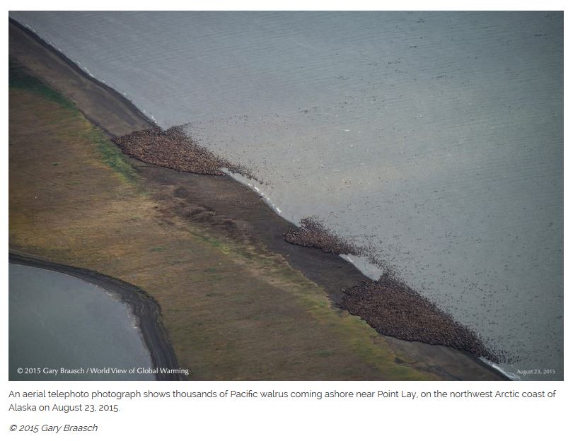
So, I guess they didn’t all die because of lack of sea ice in the Chukchi Sea. I said back on 28 August, just after the some unauthorized photos were publicized, that this haulout looked just as large as last year’s, if not larger (walruses are occasional prey of polar bears).

Walruses_USFWS photo_030515_March 2015

Now confirmed by an official US Fish and Wildlife Service estimate of 35,000 – not 36,000 mind you, or 34,000 – it was definitely 35,000. Odd, that. And surprisingly, they didn’t bother going out to count them until the day President Obama came to town. Would FWS have even bothered to get a count if there hadn’t been something newsworthy to tie it to?

Even more strange is the fact that this year, there was no accompanying hype. There were no links in any of the stories to FWS or USGS propaganda website pages, like there were last year (nor even a link to a press release). No mention of the FWS plan to have walruses declared ‘threatened with extinction because of global warming. And no mention of prosecution of the photographer who took the photos on 23 August, from the required distance, but without a permit. Note the permit number stamped on the official NOAA photo provided below (taken 2 September 2015), which few outlets carried, probably because it looks nothing like a photo of walruses on a beach:

walrus haul out NOAA Sept 2 2015

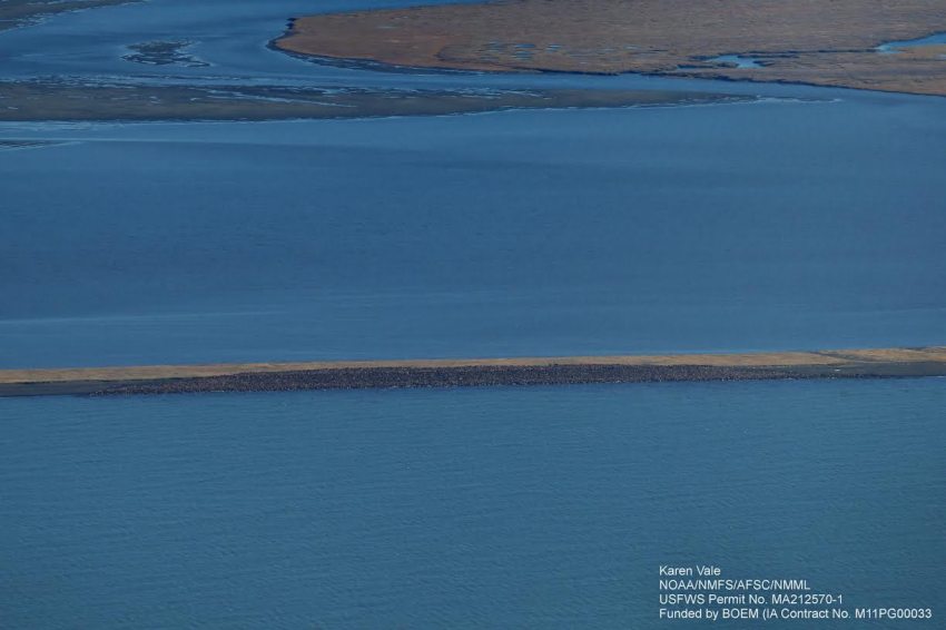
It appears that this year 35,000 walruses on a beach is a non-story. Go figure. Excerpts from the one, widely-circulated story below, from three days ago. See previous post for more walrus background, map, and video.
Continue reading

Pacific walruses hauled out at Point Lay Alaska again this year

A photo of a mass walrus haulout at Point Lay, Alaska taken a few days ago from a distance show thousands of animals. But no one’s counting because apparently, no one’s interested.

Walrus Pt Lay ADN story Aug 27 screencap
The picture on the left (above, courtesy Alaska Dispatch News) was taken 23 August by global warming activist photographer Gary Braasch, the day after a news report appeared about the US Fish & Wildlife Service and aviation authorities asking the media to approach USFWS about walrus photos and information that gave no hint that a large haulout of walruses was already in place (22 August 2015, “Federal agencies, Point Lay seek to minimize walrus disturbances” ):

“Federal agencies are stepping in to shield a North Slope village from the possibility of a deluge of international attention should a large walrus haulout develop nearby, as it has in years past — agreeing to act as an information clearinghouse on behalf of the Native Village of Point Lay.” [my bold]

Here is what the global warming activist site that published the pictures says about the haulout:

“Thousands of Pacific walrus are coming ashore near Point Lay, NW Arctic coast of Alaska. The huge sea mammals and young began coming up on this barrier island along Kasegaluk Lagoon about August 20, according to local natives. This is one of the earliest known summer haul outs of the walrus along the Alaska coast of the Chukchi Sea, according to wildlife biologists.” [my bold]

They say “thousands.” But the photos taken, reproduced in the Alaska Dispatch News story I read, were taken from a greater distance than the famous photo of ~35,000 animals released by government officials last year and looks like the total could be as large, or larger, than the 2014 haulout.

Said a Washington Post story (27 August 2015):

The U.S. Fish and Wildlife Service confirmed to the Post Wednesday evening that a mass of walruses had “hauled out,” or gathered on shore, near the remote community of Point Lay. The service did not estimate the number or provide images. But photojournalist Gary Braasch has posted dramatic photographs, taken during an Aug. 23 flyover, of what appear to be at least several thousand walruses crowding onto a barrier island.” [my bold]

Continue reading

Pacific walrus sob stories begin again

Now we have poor hunting conditions in the Bering Strait touted as evidence that “walrus migration patterns have changed” with the implication that this is because “…the past eight years have had the eight lowest amounts of summer sea ice on record” due to man-made global warming.

Walrus 2012 July USGS

A subsistence lifestyle is hard, particularly so if it depends on a highly mobile, migratory herd animal. Think Barren-ground Inuit caribou hunters, who often starved because herd sizes declined for a few years or moved unpredictably.

Many factors – seasonal weather, last year’s winter conditions, size of the herd, food supply – all affect where and when a migratory herd will move and the likelihood it will be positioned for optimal harvesting by hunters. Add another highly variable factor into that – Bering Sea ice – and you have a highly unpredictable food supply, especially if you sit in one spot (like on St. Lawrence Island) and expect that migratory herd animal to come within reach.

Hunting walrus from St. Lawrence Island depends on just the right combination of ice and winds. Too much ice is not good, too much open water is not good, and too much wind is not good.

Alaska Dispatch, courtesy the Associated Press, reports St. Lawrence natives are again short of walrus meat because of “warm temperatures”: “Warming temps push walrus north, leaving Alaska villages without traditional food source” (Rachel D’Oro, The Associated Press, August 6, 2015). And the caption of the above USGS (A. Sonsthagen) photo predictably implies all current hunting troubles can be blamed on climate channge:

“The walruses in this July 2012 file photo are hauled out in the Eastern Chukchi Sea. Walrus migration patterns have changed as sea ice and other environmental factors have shifted — and that’s spelled trouble for Alaska Native communities who hunt them for subsistence.”

The people of St. Lawrence Island and the Bering Strait that depend on walrus for subsistence have my sympathy, they indeed have a hard life – but this is not a tale of woe about the status of Pacific walrus and changing summer sea ice.

Bering Strait natives hunt walrus in spring, from mid-April to early June (Huntington et al. 2013). All indications are that walrus are moving differently than they used to in summer because the population is now very large.  As far as I know, there is no new population information on walrus that wasn’t available last year, when I covered this topic extensively (Crockford 2014; video below).


Continue reading

Alarm over future summer polar bear habitat disguises how good conditions are right now

Despite the public outcry last week over future polar bear survival, the polar-bears-are-doomed crowd can’t hide the fact that this year, spring sea ice habitat for polar bears worldwide has been excellent.

A polar bear walks on the Arctic Ocean ice Aug. 21, 2009.

This year on 19 July, for example, Hudson Bay had greater than 150,000 square km more sea ice than there was in 2009 on that date (526.2 vs. 368.5 mkm2)(1992 was a particularly cold year and most bears left the ice as late in 2009 as they did in 1992).1 Conditions have also been excellent for pregnant females around Svalbard – Norwegian polar bear researchers recently reported a good crop of cubs this spring.

Hudson Bay breakup July 20 2015_CIS

Worldwide, there was exactly the same amount of Arctic sea ice present on 18 July 2015 as there was back in 2006 (Day 199) – 8.4 mkm2. By 19 July (day 200), 2015 had more ice than 2006 (8.4 mkm2 vs. 8.3).

All this means that recent summer ice melt has not impinged on the spring feeding period that is so critically important for polar bears. So much ice left in early summer means there was lots of sea ice in the spring (April-June), even in the Southern Beaufort Sea.

The only region with sea ice coverage well below the last five years is the Chukchi Sea (see plots below, click to enlarge). So why aren’t we hearing the-sky-is-falling stories about Chukchi bears? Because biologist have already demonstrated that polar bears in the Chukchi do very well even with no summer sea ice.
Continue reading

Polar bears fine now but give us more money: US Fish & Wildlife Management Plan subtext

Between-the-lines message of the recently released (and hyped to death) Conservation Management Plan for polar bears by the US Fish & Wildlife Service is that the bears really have nothing to worry about except human-caused global warming but it will cost tens of millions of dollars over the next five years to study and manage them.

polar_bear_usfws_no date_sm

So filled with double-speak, misinformation, and obfuscation [including the newly-invented term, “quasi-extinction floor”] that it’s no wonder some news outlets got it wrong (nowhere in this document does it say that polar bears might go extinct within ten years“). The document does, however, lay out the FWS budget for polar bears over the next five years – and it’s a real eye-opener.

Continue reading

Tracking polar bears in the Southern Beaufort June 2015 – all 17 bears out on the sea ice

Sixteen females with satellite collars plus one with a glue-on transmitter – down from 17 with collars and 6 with tags last month – all out on the ice during the month of June 2015.

Tranquilized_pb570_S Beaufort March 2014_USGS

Polar bears were captured by USGS biologists in 2014 and 2015 on the spring-time sea ice of the southern Beaufort Sea. The glue-on tags don’t seem to be holding up very well, with only one remaining out of the original eight deployed this spring.
Continue reading

Tracking polar bears in the Southern Beaufort May 2015 – thick ice and polynyas

Polar bear habitat in the Southern Beaufort for May 2015 was a contrast between the development of recurring polynyas (patches of open water) and tremendously thick sea ice. So it’s interesting to see where the polar bears tagged by USGS biologists chose to hang out.

Polar_Bear_Biologist_USFWS_working_with_a_Bear_Oct 24 2001 Amstrup photo

The total number of bears being tracked in May – 23 – is down markedly from the 30 bears USGS biologists started with in April.

Most of the collared bears were concentrated in May along the shore lead (crack of open water) that normally develops between the shorefast ice and the pack ice offshore. That’s especially understandable this year, since most of that pack ice is 3-5 m thick (10-16 ft) – see the maps below.
Continue reading

Tracking polar bears in the Southern Beaufort, with a sea ice surprise – April 2015 map

USGS biologists were clearly busy this spring putting more satellite radio collars and glue-on tags on Southern Beaufort Sea polar bears but there’s some surprising information in their April 2015 tracking map about current sea ice conditions.

From the 2013-2014 issue of  “Polar Bear News” (USFWS).

From the 2013-2014 issue of “Polar Bear News” (USFWS).

What’s interesting is that the sea ice maps they use show less dark spots that might be open water this year than were present last year in late April. Oddly, this phenomenon has one prominent biologist worried about “challenging” polar bear habitat developing this year – without mentioning last year at all.

The USGS track map for April 2015 is copied below.1
Continue reading

Melt season update – Bering Sea ice abundant & Davis Strait ice 2nd highest since 1971

Polar bear habitat in the eastern Bering Sea has expanded since the official spring “maximum extent” was called for late February, and Davis Strait sea ice is tied for 2nd highest since 1971 for this week. Both regions have healthy polar bear populations and spring conditions suggest this will continue into this year.

Rode and Regehr 2010_Chukchi_report2010_Fig1_triplets_labelled

Although the melt season is underway, as of yesterday (22 April, Julian day 112) overall Arctic sea ice extent (Fig. 1) was higher than it was on the same date in 2014, 2007, and 2004 (see also Fig. 2). Despite the record low extent in February (Fig. 3), that pessimists at Polar Bears International suggested was relevant to polar bear heath and survival, I showed that was misleading.

Figure 1. Sea ice extent at 22 April (Julian day 112) for 2015, at 13.976 mkm2, was well within 2 standard deviations and higher than 2007 (shown) as well as 2004 and 2014 (not shown – see it for yourself here).

Figure 1. Sea ice extent at 22 April (Julian day 112) for 2015, at 13.976 mkm2, was well within 2 standard deviations and higher than 2007 (shown), as well as higher than 2004 and 2014 (not shown – see it for yourself here). Click to enlarge.

Sea ice maps and charts tell the story of current polar bear habitat throughout the Arctic.
Continue reading

Tracking polar bears in the Beaufort Sea – March 2015 map

Here is the March 2015 follow-up to my post on the July 2013 track map for female polar bears being followed by satellite in the Beaufort Sea by the US Geological Survey (USGS) – “Ten out of ten polar bears being tracked this summer in the Beaufort Sea are on the ice.”

putting_collar_on_polar_bear_slider_USGS

See that post for methods and other background on this topic, and some track maps from 2012 (also available at the USGS website here). The USGS track map for March 2015 is copied below.

Three out of eight female bears tagged in the Southern Beaufort Sea were in the Chukchi Sea subpopulation region during March – not surprising, many bears cross this “boundary.”
Continue reading